
The National Weather Service in North Webster is advising that heavy rain is forecast to move in late Wednesday, with a Slight Risk (level 2/4) for excessive rainfall/flooding across all of Marshall County. Rain totals will be 1 to 2 inches, with the highest totals north of U.S. 6.
Marshall County residents may see flooding in low-lying areas that are susceptible to flooding during heavy rain events. Some ditches and creeks may see an increase in water levels. Ponding on road surfaces could cause hazardous driving conditions.
People living in flood-prone locations should move their vulnerable property to higher ground, closely monitor the forecast and be prepared to implement their family emergency plan. While driving, be alert to water ponding on top of or near the edge of roads that may be difficult to see especially at night. Never drive through high water. Turn around and find a safer route.
 May primary ballots set for Vermillion County
 SW Parke identifies 'Big Five' themes for Revision Project
 Lucas Oil named title partner of 500 Festival Parade
 Applications open for new United Way of Central Indiana initiative to build community solutions
 Utilities District of Western Indiana REMC announces increases over next three years
 Fountain County man arrested on sex crime charges, Parke County investigation remains
 Friday is National Wear Red Day
 Vermillion County DCS worker facing felonies
 One week left to file for office in Indiana
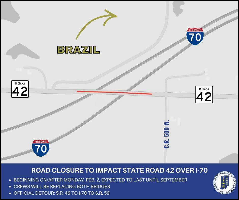 Bridge closures to impact State Road 42 over I-70 in Clay County
 Road renaming resolution co-authored by Criswell to honor Bobby Knight passes House
 Thrive West Central to host Utility Workshop
 Greene Realty continues to grow
 World Food Championships set for 2026 Indianapolis return
 NWS extends Winter Storm Warning to Monday morning
 IDHS activates State Emergency Operations Center in response to winter storm