News
The National Weather Service has issued a STRONG THUNDERSTORM WILL IMPACT MARSHALL COUNTY
at about 5:15 PM.
At 427 PM EDT/327 PM CDT/, Doppler radar was tracking a strong
thunderstorm near Ora, or 9 miles northeast of Winamac, moving
northeast at 30 mph.
HAZARD...Wind gusts up to 50 mph and half inch hail.
SOURCE...Radar indicated.
IMPACT...Gusty winds could knock down tree limbs and blow around
unsecured objects. Minor hail damage to vegetation is
possible.
Locations impacted include...
Plymouth, Bremen, Knox, Bourbon, Argos, Culver, Walnut, Tippecanoe,
Oak Grove, Monterey, Leiters Ford, Ober, Twin Lakes, Inwood, Rutland,
Burr Oak, Maxinkuckee, Hibbard, Winona, and Delong.
PRECAUTIONARY/PREPAREDNESS ACTIONS...
If outdoors, consider seeking shelter inside a building.
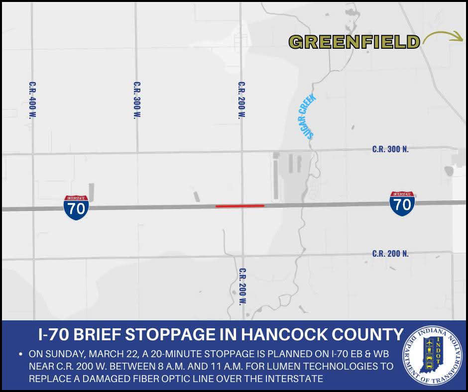 I-70 stopped Sunday in Hancock County
 Pleasant View Road bridge over I-74 to close for bridge replacement in Shelby County
 Experienced Parke Heritage next up for Triton Central
 Shelbyville's Harry Larrabee inducted into Indiana Basketball Hall of Fame
 February real estate market provides positive outlook for spring season
 SCS hosting educational workshop on online predators
 Safe Zones enforcement to begin on I-74
 VA announces $112M grant opportunity to strengthen community-based suicide prevention efforts